 |
| ILWIS |
Integrated Land and Water Information System (ILWIS) is a data processing software based Geographic Information System (GIS). ILWIS is used as a means of inputting data, the data management and data analysis to produce output in the form of geographical data in a region. This software is made by the International Institute for Aerospace Survey and Earth Sciences, the Netherlands.
Model data in ILWIS divided into vector and raster data. In ILWIS software there are two major components and WIndows ILWIS ILWIS object.
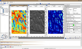
ILWIS WIndows consists of main windows, folder windows, tables windows and pixel information. Main Windows is the main window that serves as the main control of all the activities this ILWIS software. Main windows there is a menu bar, command line, catalog, operation and operation tree list, navigator, standard toolbar, object selection toolbars, status bars. Windows folder is a window that contains data in the form of vector and raster as the input data. Windows table contains data in tabular form the information of spatial data or attribute data. While the pixel information contains information about classes, IDs, attributes of the spatial data.
ILWIS object contains a data object, container objects and spacial object. ILWIS object data consists of spatial data and attribute data. Spatial data contains point folder, folder segment, polygon and raster map folder located in windows folder. While the data attributes that are formed from the table and lies on the table window. Container object is a reference list of a number of data objects. And spacial object contains the histogram, sample sets, 2-dim tables, matrices, filters, function, scripts and stereo pairs.
The software is also compatible with other GIS software such as ArcView can be opened directly in this ILWIS software.
Download software
http://www.ilwis.org/open_source_gis_ilwis_download.htm


0 komentar:
Posting Komentar