 |
| How to coordinate in a raster map |
1. download tool registers "transform.avx" first
2. copy tool registers "transform.avx" into the installation as "C: \ ESRI \ AV_GIS30 \ ArcView \ EXT32"
3. Open ArcView
4. open a new view> Doc Project> TOC> select List View (double-click/tekan New button)> will display the document View1
5. jpg extension add and register by clicking File> Extensions then check in "JPEG (JFIF) Image Support" and "Register and Transform Tool"
6. enter data / raster map images in a way menu view> Add Theme
7. search the directory to store raster map
8. after opening raster maps give a point of reference to which there are four coordinates have been determined (give a reference point to the intersection of longitude and latitude to form 4 points)
9. note the reference point in x (longitude) and y (latitude)
10. convert from DMS (Degree Minute Second) in DD (Decimal Degree)
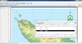
11. click menu view> regiter and transform> Registers window will then appear and Transform
12. click on the tool point source located in the middle of the> mark the points in a clockwise direction
13. after marking add destination using the results that had been sought out and make sure the state of the edit mode
14. after rms error is <12:14 then select the file and then place the world write to existing directory
15. then load raster map and world map in arcview


0 komentar:
Posting Komentar